Skip to content Skip to navigation

Services

x

Error message

  • Deprecated function: The each() function is deprecated. This message will be suppressed on further calls in menu_set_active_trail() (line 2396 of /home2/blackfie/public_html/includes/menu.inc).
  • Notice: Trying to access array offset on value of type int in element_children() (line 6527 of /home2/blackfie/public_html/includes/common.inc).
  • Notice: Trying to access array offset on value of type int in element_children() (line 6527 of /home2/blackfie/public_html/includes/common.inc).
  • Notice: Trying to access array offset on value of type int in element_children() (line 6527 of /home2/blackfie/public_html/includes/common.inc).
  • Notice: Trying to access array offset on value of type int in element_children() (line 6527 of /home2/blackfie/public_html/includes/common.inc).
  • Notice: Trying to access array offset on value of type int in element_children() (line 6527 of /home2/blackfie/public_html/includes/common.inc).
  • Notice: Trying to access array offset on value of type int in element_children() (line 6527 of /home2/blackfie/public_html/includes/common.inc).
  • Notice: Trying to access array offset on value of type int in element_children() (line 6527 of /home2/blackfie/public_html/includes/common.inc).
  • Notice: Trying to access array offset on value of type int in element_children() (line 6527 of /home2/blackfie/public_html/includes/common.inc).
  • Notice: Trying to access array offset on value of type int in element_children() (line 6527 of /home2/blackfie/public_html/includes/common.inc).
  • Notice: Trying to access array offset on value of type int in element_children() (line 6527 of /home2/blackfie/public_html/includes/common.inc).
  • Notice: Trying to access array offset on value of type int in element_children() (line 6527 of /home2/blackfie/public_html/includes/common.inc).
  • Notice: Trying to access array offset on value of type int in element_children() (line 6527 of /home2/blackfie/public_html/includes/common.inc).
  • Deprecated function: implode(): Passing glue string after array is deprecated. Swap the parameters in Drupal\gmap\GmapDefaults->__construct() (line 107 of /home2/blackfie/public_html/sites/all/modules/gmap/lib/Drupal/gmap/GmapDefaults.php).
  • Deprecated function: implode(): Passing glue string after array is deprecated. Swap the parameters in drupal_get_feeds() (line 394 of /home2/blackfie/public_html/includes/common.inc).
  • Notice: Trying to access array offset on value of type int in element_children() (line 6527 of /home2/blackfie/public_html/includes/common.inc).
  • Notice: Trying to access array offset on value of type int in element_children() (line 6527 of /home2/blackfie/public_html/includes/common.inc).
  • Notice: Trying to access array offset on value of type int in element_children() (line 6527 of /home2/blackfie/public_html/includes/common.inc).
  • Notice: Trying to access array offset on value of type int in element_children() (line 6527 of /home2/blackfie/public_html/includes/common.inc).
  • Notice: Trying to access array offset on value of type int in element_children() (line 6527 of /home2/blackfie/public_html/includes/common.inc).
  • Notice: Trying to access array offset on value of type int in element_children() (line 6527 of /home2/blackfie/public_html/includes/common.inc).
  • Monitor Natural Resources

    Our software technology offers you an affordable solution to create accurate and timely mosaics and models from any imagery or camera. Blackfields’ mapping software will enable you to create extensive inventories of natural resources, verify the...

  • Environmental

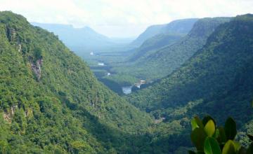
    Drones are ideal tools for monitoring wildlife, studying the environment or carrying out anti-poaching patrols. Drones can fly lower and slower than manned aircraft and are much quieter, enabling researchers to observe animals at relatively close range with minimal...

  • Geographical Information System (GIS)

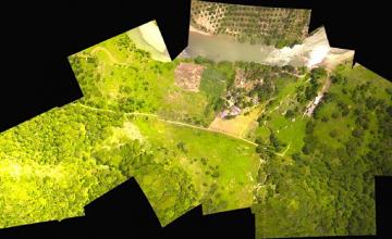
    Drone technology allows GIS professionals to work more efficiently. With an easy-to-deploy mapping drone you can capture accurate aerial imagery and transform it into 2D orthomosaics (maps) and 3D models of small- and medium-sized sites – all on demand and...

  • Agriculture

    Our Drones can capture highly accurate images of your fields, covering up to hundreds of hectares/acres in a single flight. Without the cost and hassle of manned services. At a far greater resolution than satellite imagery provides, even when there is cloud cover....

  • Mineral Mining and Quarry Operations

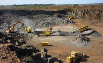
    Anyone involved in mining knows that worker safety is of paramount importance. By allowing surveyors to collect accurate spatial data from above, drone or UAV technology can vastly reduce risk by minimising the time these staff spend on site.

    Drone-based data collection can also...

  • Surveying and Mapping

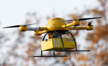
    Blackfields’ Unmanned Aerial Systems (UAS), provide an integrated end-to-end surveying and GIS (Geographical Information System) solution. The immediate and reliable collection of high quality aerial imagery and a variety of image processing options give everyday users and GIS specialists the...